Filter: Categories of Wisconsin Historical Images
Filter: COLLECTION_NAME of Manuscripts
Filter: Categories of Wisconsin Historical Images
Filter: COLLECTION_NAME of Manuscripts
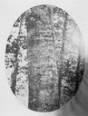
| Date: | |
|---|---|
| Description: | A beech tree with the inscription, "D. Boon cilled a bar. 1760" carved into it. The tree was located up to the 1880s near Boone's Creek, Tennessee. |

| Date: | 1744 |
|---|---|
| Description: | A map of a plan of 16,500 acres of land. |
| Date: | 1876 |
|---|---|
| Description: | A map of the site of the Battle of Point Pleasant. |
| Date: | 1804 |
|---|---|
| Description: | Front cover of the 55-page diary, from May 14 through August 17, 1804 written by Charles Floyd, a sergeant with the Lewis and Clark expedition. |

| Date: | 1780 |
|---|---|
| Description: | Hand-drawn plan for the layout of the town of Clarksville, bordering Mayfield Creek and Liberty Creek. Fort Jefferson is shown between the townsite and the... |

| Date: | 1780 |
|---|---|
| Description: | Plan for layout of 150,00 acres which make up Clark's Illinois Grant. |
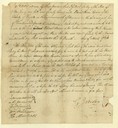
| Date: | 03 15 1783 |
|---|---|
| Description: | Letter written by Gilbert Imlay regarding Daniel Boone. |
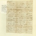
| Date: | 1786 |
|---|---|
| Description: | Body of a letter written by Gilbert Imlay to Colonel Daniel Boone. |
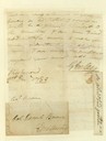
| Date: | 1786 |
|---|---|
| Description: | Letter written by Gilbert Imlay to Daniel Boone. |

| Date: | 1790 |
|---|---|
| Description: | Map of the region surrounding Dayton, Ohio showing rivers and other settlements, with a table of distances from Cincinnati to Dayton and to points outside ... |
| Date: | 02 24 1779 |
|---|---|
| Description: | Letter from Colonel George Rogers Clark to Lieutenant Governor Henry Hamilton demanding unconditional surrender of Fort Vincennes. |

| Date: | 08 24 1876 |
|---|---|
| Description: | Hand-drawn plan of the battleground of Huycks. |

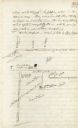
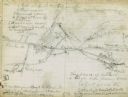
| Date: | 03 26 1876 |
|---|---|
| Description: | Hand-drawn map showing the place of Hook's defeat in York County in South Carolina. |
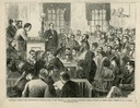
| Date: | 12 23 1871 |
|---|---|
| Description: | Illustration of Dr. Williams being sworn in as an expert medical witness at the Wharton trial. |
| Date: | |
|---|---|
| Description: | Plat map of Mammoth Cave. A note on the map reads: "Mrs. Campbell conjectures that this is a saltpeter cave in Green River, Kentucky. The mummy found in it... |
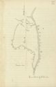
| Date: | |
|---|---|
| Description: | Drawn map of the Catawba River, fishing creek, and surrounding landscape from the Sumter Papers. |
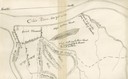
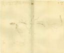
| Date: | |
|---|---|
| Description: | Drawn map of Landsford, South Carolina, from Thomas Sumter Papers. |
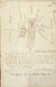
| Date: | |
|---|---|
| Description: | Drawn map of the Hanging Rock Battlefield in the Thomas Sumter Papers. |
If you didn't find the material you searched for, our Library Reference Staff can help.
Call our reference desk at 608-264-6535 or email us at: